Note
Go to the end to download the full example code
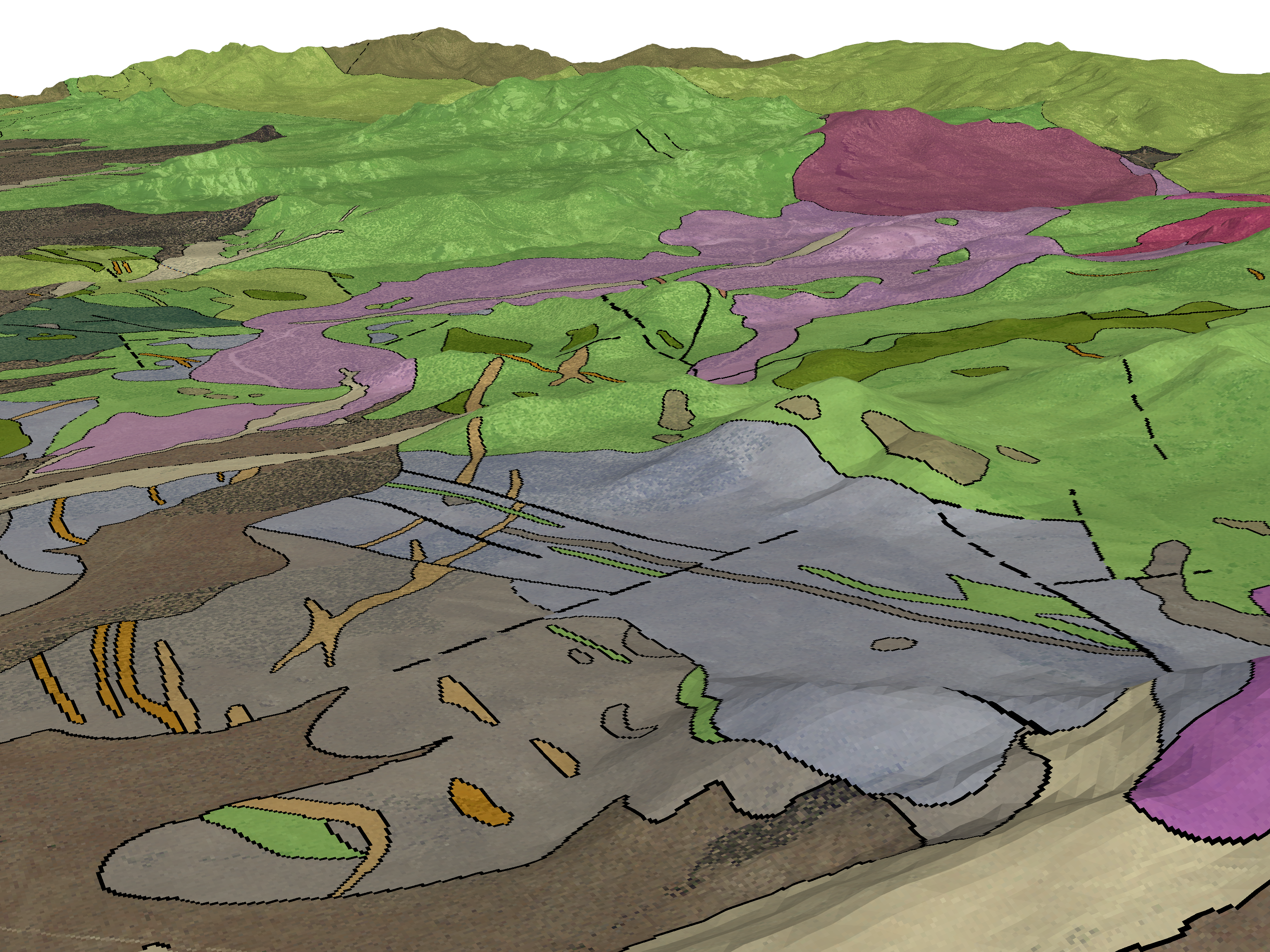
Geological Map on Topography
Texture mapping for a GeoTIFF on a topography surface.
To overlay an image/map from a GeoTIFF on to a topography surface, it’s necessary to have texture coordinates (“texture mapping”) matching the proper extents of the mesh/surface you’d like to drape the texture (GeoTIFF) on.
We can do this by using the spatial reference of the GeoTIFF itself, as this allows you to preserve the entire mesh that the texture is being draped on without having to clip out the parts where you don’t have imagery. In this example, we explicitly set the texture extents onto a topography surface where the texture/GeoTIFF has a much larger extent than the topography surface.
Originally posted here: pyvista/pyvista-support#14
# sphinx_gallery_thumbnail_number = 2
import numpy as np
import pooch
import pyvista as pv
import rasterio
url = "https://raw.githubusercontent.com/pyvista/vtk-data/master/Data/topo_clean.vtk"
file_path = pooch.retrieve(url=url, known_hash=None)
topo = pv.read(file_path)
topo
Load the GeoTIFF/texture https://dl.dropbox.com/s/emsg3h7hww1r779/Geologic_map_on_air_photo.tif?dl=0
url = "https://dl.dropbox.com/s/emsg3h7hww1r779/Geologic_map_on_air_photo.tif?dl=0"
filename = pooch.retrieve(url=url, known_hash=None)
filename
'/home/runner/.cache/pooch/283a4c8495d964af0cfed0f875375923-Geologic_map_on_air_photo.tif'
def get_gcps(filename):
"""This helper function retrieves the Ground Control
Points of a GeoTIFF. Note that this requires gdal"""
get_point = lambda gcp: np.array([gcp.x, gcp.y, gcp.z])
# Load a raster
src = rasterio.open(filename)
# Grab the Groung Control Points
points = np.array([get_point(gcp) for gcp in src.gcps[0]])
# Now Grab the three corners of their bounding box
# -- This guarantees we grab the right points
bounds = pv.PolyData(points).bounds
origin = [bounds[0], bounds[2], bounds[4]] # BOTTOM LEFT CORNER
point_u = [bounds[1], bounds[2], bounds[4]] # BOTTOM RIGHT CORNER
point_v = [bounds[0], bounds[3], bounds[4]] # TOP LEFT CORNER
return origin, point_u, point_v
# Fetch the GCPs
origin, point_u, point_v = get_gcps(filename)
# Use the GCPs to map the texture coordinates onto the topography surface
topo.texture_map_to_plane(origin, point_u, point_v, inplace=True)
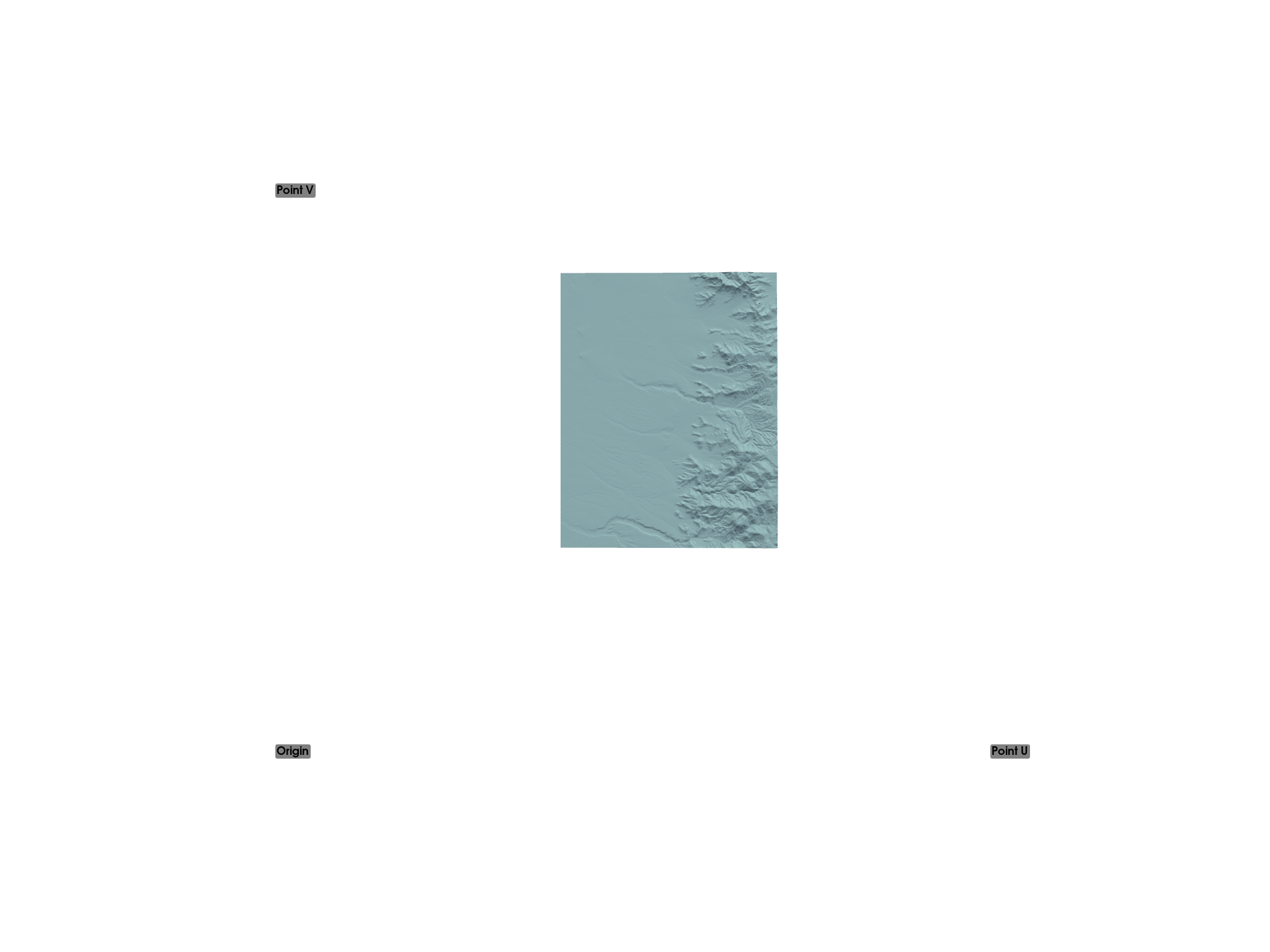
# Show GCPs in relation to topo surface with texture coordinates displayed
p = pv.Plotter()
p.add_point_labels(
np.array(
[
origin,
point_u,
point_v,
]
),
["Origin", "Point U", "Point V"],
point_size=5,
)
p.add_mesh(topo)
p.show(cpos="xy")
Read the GeoTIFF as a Texture in PyVista:
texture = pv.read_texture(filename)

# Now plot the topo surface with the texture draped over it
# And make window size large for a high-res screenshot
p = pv.Plotter(window_size=np.array([1024, 768]) * 3)
p.add_mesh(topo, texture=texture)
p.camera_position = [
    (337461.4124956896, 4257141.430658634, 2738.4956020899253),
    (339000.40935731295, 4260394.940646875, 1724.0720826501868),
    (0.10526647627366331, 0.2502863297360612, 0.962432190920575),
]
p.show()
Total running time of the script: (0 minutes 20.068 seconds)